What exactly is a Watershed?
It doesn’t matter where you live—on a farm or in the city, on
the seashore or in the mountains, in the woods or even in the
desert—you live in a watershed. A watershed is defined by the topography
around you. All the rain or snow that falls in your neighborhood drains
toward a body of water. In our case, that’s Watkins Creek. And then,
of course, Watkins Creek flows into a larger body of water, the
Mississippi, which then flows into the Gulf of Mexico…it’s all
connected. From your backyard to the ocean.
How does a healthy Watkins Creek Watershed affect my neighborhood?
• Provides a natural water filter and helps to provide
clean drinking water
• Reduces erosion
• Helps control stormwater and flooding
• Provides space for recreational areas including
hiking, swimming and fishing
• Naturally cools the air
• Increases property value
• Promotes economic growth
• Provides water for industry and transportation
We forget that the water cycle and the life cycle are one.
Jacques Cousteau
For a printable version, please click here.
Access Points to Watkins Creek in Spanish Lake and Unincorporated St. Louis County East of Highway 367
These access points begin where Watkins Creek empties into the Mississippi River and then head up the creek eventually ending up on the eastern side of Highway 367 and Dunn Road. In those areas where the access points are on private property – or where there is clearly a house visible – make sure you talk with the property owner first.
1. Mouth of Watkins Creek at the Mississippi River Access
Enter on the Metropolitan Sewer District property on the east side of Riverview Drive a bit north of I-270. Park there and head east to the Mississippi River. Do not leave the sewer district property.
2. Watkins Creek Bridge on Riverview Access
Stay parked on the Metropolitan Sewer District property and walk north. This bridge is located just a bit north. There is good access to the creek on both the east and west sides of Riverview.
3. Coal Bank Road Access
You can gain access to this bridge over Coal Bank, which again affords good access to the creek on both sides of the bridge, two ways. First, you can drive west up Coal Bank Road from Riverview and park where the street is blocked. Then walk a little bit to the bridge.
Or, you can enter by heading west on Dunn, north on Lilac and south on Coal Bank directly to the bridge. You will see the road blockade a bit ahead of you.
4. Dunn Road Access
From Riverview Boulevard, head west on Dunn Road. There is good access to the creek on the north side of Dunn along the property line just west of the house at 791 Dunn Road.
5. Fry Lane Bridge Access
Continue west on Dunn Road to Lilac. Turn left or south on Lilac, over I-270. First there will be the entrance to travel east on the interstate, then there will be the access road south of I-270 and then almost immediately is Fry Lane – very easy to miss. It is a one lane road on the east side of Lilac that until recently was a dirt road.
Turn left on Fry Lane, past a few houses and in a bit you will be at a bridge over the creek. There is good access on both sides of the bridge. There are no immediate buildings there, but a bit further on a construction company has taken over an old homestead and has turned it into a business site so you may find that as you head in this road, there may be a construction truck coming out. Just try and move over!
6. Bellefontaine Estates Access
Head west out of Fry Lane to Lilac and turn south. Enter the new development named Bellefontaine Estates. There is not much construction going on there right now. Watkins Creek is part of their property and is located on the southern and eastern end of this new development. Park at the last house and start walking across the field. You’ll find the creek.
7. Lilac Road Access
Head out of Bellefontaine Estates towards Lilac and head south. A bit past the Plumbers and Pipefitters’ Training Center, Lilac crosses Watkins Creek. There is access there.
8. Belgrove Road Access
Turn around and head north up Lilac. Before you get to I-270, Belgrove will come in on the west. Turn left on Belgrove until you get to the railroad trestle over the road. There is good access to the creek there.
9. Raftery Lane Access
Continue west on Belgrove to Raftery Lane which is on the north side. There is very good access to the creek along the west side of the property at 10919 Raftery Lane.
10. Bellefontaine Road Access south of I-270
Take Belgrove west to Bellefontaine Road and turn north, or right. Continue to BP gas station, just south of I-270, and pull in behind Burger King and in front of the Down Home Restaurant there. Access to the creek is along the north side of the parking areas.
11. Dunn Road Access
Head back to Bellefontaine Road and turn north, or right. You will want to make a left turn immediately after going under I-270, so get in the left lane. Turn west, or left on Dunn Road and stay in the right lane – you will not want to enter I-270 heading west. On the north or right side of Dunn, there is an abandoned Burger King restaurant. Pull in there and park. Access to the creek is on the northeast side of that property.
12. Northgate Estates Accesses
Turn around and head back to Bellefontaine Road. Turn north or left to Claudine. Turn west or left on Claudine into Northgate Estates.
There are many points of access all along Claudine since Watkins Creek is on the southern border of this subdivision. In a number of cases the Londoff/GEM store property (which is not developed and where access is on the north side of Dunn), actually extends on the north side of Watkins Creek in a number of places, behind the private homes along Claudine. It will be easy for you to see the access points – most are on the south side, but there are one or two on the north side.
13. Dunn and Lusher – the Eastern Outer Road of I-270
Continue west on Claudine to the traffic light. There you will find access to the “creek” – after it comes out from under I-270 – on the east side of Dunn. You can also see it looking south at the intersection there with Claudine. Again, good access.
To view the Watkins Creek Watershed study, click here.
EPA Grant Spurs Hands-on Learning
Residents of Spanish Lake will soon be asked to join with other North St. Louis County neighbors in a newly funded initiative to assure clean water in our area for years to come. The effort springs from a federally funded program to engage the community of Watkins Creek Watershed in a three year, $666,000 public/private partnership. The Watkins Creek Demonstration Project will implement information/education programs in the watershed to educate the students, their families, local municipal leaders, and the general public about urban stream issues, nonpoint source pollution, and best management practices to control urban stormwater runoff. The federal funding for the project is provided by the Environmental Protection Agency, Region 7, 319(h) Nonpoint Source Implementation Grant through the Missouri Department of Natural Resources.
Watkins Creek, a small six-mile urban stream, surfaces in the City of Black Jack coursing through the Spanish Lake/Glasgow area and Bellefontaine Neighbors on its way to the Mississippi River. Besides the Spanish Lake Community Association, the partnership includes the Hazelwood School District, Metropolitan Sewer District (MSD), St. Louis Soil and Water District and the Missouri Botanical Gardens (MOBOT). It is led by RegionWise, an urban Center in the College of Public Service at Saint Louis University. Other participants are St. Louis County and Missouri American Water. SLU and its partners have committed 40 percent in required local match.
Hazelwood school district will receive approximately $200,000 to construct natural stormwater control features on the campuses of its four new middle schools, scheduled to open beginning this month. Stormwater management practices like bio-swales, streambank bio-retention structures, rain gardens, and riparian corridor restoration will be demonstrated on the four school sites to show some effective measures to address urban nonpoint pollution issues created by excess stormwater runoff. These features, identified by the EPA as best management practices for urban site development, will be integrated into the school district’s MSD approved storm water system. The demonstrations will offer students and interested residents real life examples of the ways in which natural water systems behave, as well as how to reduce stream bank erosion. Parsons & Brinkerhoff, the school district’s lead architectural firm is handling the site design, as well as assisting with oversight of the building projects.
The BioSwales and Community Rain Gardens will serve as outdoor classrooms for student science learning while aiding the return of rainwater naturally to the watershed system. Planting of the Rain Gardens will offer a community wide event bringing together students, families and others interested in learning how to recreate the attractive natural features in their own back yards. Volunteers will receive training from Missouri Botanical Gardens and have one-time or ongoing opportunities to participate in planting and maintenance of the native community gardens.
Recommendations concerning Watersheds
from the I-270/Highway 367 Corridor Study
Adopted by the St. Louis County Council
October 2003
II. EXECUTIVE SUMMARY
General Policy Recommendations:
Issues of general concern for the entire study area include beautification, code enforcement, community identity and watershed management.… Ensuring that new development and redevelopment efforts do not harm local watersheds is another goal of the study. A cooperative effort among many organizations including the Metropolitan Park and Recreation District, RegionWise and StreamTeach, Inc. is in progress to preserve and enhance the Watkins Creek watershed that lies within the study area.
V. GENERAL POLICY RECOMMENDATIONS2
Four issues of general concern became apparent during the development of I-270/ Highway 367 Corridor Study. They are: beautification, code enforcement, community identity and the Watkins Creek watershed. These subjects affect the general condition of the area and have an effect on land use and development throughout the corridors.
Watkins Creek Watershed3
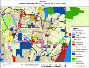
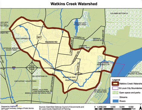
The I-270/Highway 367 study area includes portions of three watersheds: Coldwater Creek (north section of Highway 367), Maline Creek (southern portion of Highway 367 and eastern portion of I-270), and Watkins Creek (eastern section of I-270 and middle section of Highway 367). Unlike the very large Coldwater Creek and Maline Creek watersheds that cover significant portions of St. Louis County, the Watkins Creek watershed is contained entirely within the vicinity of the study area. Watkins Creek begins just south of Parker Road in the Black Jack area, continuing southeastwardly under Highway 367 and looping south and then north of I-270 before emptying into the Mississippi River. The Watkins Creek watershed includes approximately 4,300 acres, and there is undeveloped land along its course south of I-270 and near the Mississippi River.
A cooperative effort is underway to preserve and enhance the Watkins Creek watershed. The Watkins Creek Task Group includes representatives of the Confluence Greenway, , East-West Gateway Coordinating Council, Hazelwood School District, Metropolitan St. Louis Sewer District, Missouri Department of Conservation, RegionWise, St. Louis Earth Day, Soil and Water Conservation District of St. Louis County, Spanish Lake Community Association, StreamTeach, Inc., Trailnet, and USDA Natural Resource Conservation Service. Several recommendations from the task group are included here to assist in preservation of Watkins Creek. These recommendations are included for reference purposes only.
Recommendation 1
New development and redevelopment plans should include a watershed impact
assessment to ensure economic, aesthetic and scientific integration with other area plans (e.g., Confluence Greenway – see Section III D). This may include, but is not limited to, the following:
Preserve Viewsheds
Because Watkins Creek borders the Confluence Greenway, further developments should be designed to benefit from and contribute to its ecological restoration and related economic development. The intersection of I-270 and Riverview Boulevard may become a major entrance to the Columbia Bottom Conservation Area and Confluence Point, as well as a destination for interpretive information about the Missouri and Mississippi Rivers and environmental, heritage education and research programs (refer to the Confluence Greenway plan for details).
Create Buffers
Because the study area is largely built out, great care must be taken to set aside buffers along the creek as new development comes into the watershed to prevent increased flooding for the residences and buildings downstream.
Reduce Impervious Surfaces
In commercial site design, the surface area of parking lots should be shrunk incrementally and the space saved should be used to integrate functional landscaping and better stormwater treatment within the parking lot. Design adjustments may include less aggressive site designs in terms of parking and building coverage, limiting excess parking, incrementally reducing parking demand ratios, and using grid pavers for spillover parking areas.
In residential site design, consideration should be given to the following: use of narrower, shorter streets and rights-of-way; application of smaller lots and setbacks and narrow frontages to preserve significant open space; reduction of the amount of site area devoted to residential lawns, spreading stormwater runoff over pervious surfaces; use of open channels rather than curbs and gutters; and protection of stream buffers.
Recommendation 2
Integrate Watershed Impact Information with Communication Plans
In public announcements of development projects, watershed impact information should be included. Studies show that property values increase when residents have knowledge that public actions are taken to protect the environmental amenity in which they are invested.
Recommendation 3
Align Economic Development Plans with the Watershed Development Plan
The Watkins Creek Task Group is supporting the creation and implementation of a comprehensive watershed plan for Watkins Creek. It is beginning this work with a collaboration of organizations that are seeking to engage stakeholders in activities that will contribute to a strong grassroots effort to protect and enhance the watershed.
POLICY GUIDELINES FOR SUBAREAS4
SUBAREA 1: I-270/LILAC AVENUE – AREA IC Southeast Quadrant of I-270/Lilac Avenue
Recommendation
3. Promote open space links along Watkins Creek as a design feature and amenity for possible future connection to other areas. New developments should employ open space design techniques to reduce the amount of impervious surface and improve the performance of storm water treatment practices.